Oslo Livability Programme

Oslo Livability Programme

Whether people want to spend time in public urban spaces depends on their accessibility and safety. The 2014 survey of urban space use in Oslo revealed that connectivity, accessibility, and appearance of urban space in Oslo need to be improved. As a result, Livability Program was launched to create a greener and more livable city. The vision was that streets and squares would turn into safe and attractive meeting places featuring cafes with terraces, playgrounds, and urban art installations. 
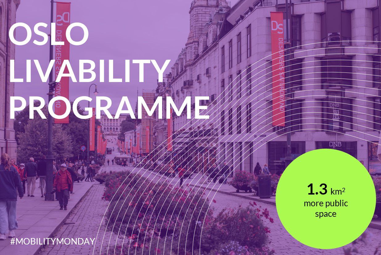
One of the most important measures was to increase street safety by reducing the number of parking spaces in the city center, as well as the expansion of public transport services and the development of a more favorable pricing policy. In 2018, 760 parking spaces in the city center were substituted by 1.3 km2 of bike paths, benches, and parks. In 2019, Oslo achieved Vision Zero: zero pedestrian and cyclist fatalities in the city center. It is expected that the proportion of citizens who travel by car will decrease by 33% by 2030. This will help achieve the goal of the Norwegian Climate Strategy, which is to reduce greenhouse gas emissions by 95% by 2030.
Madrid Better Life in Metropolis

Madrid Better Life in Metropolis

Madrid? We think it’s great! Not only because we have an office here, but also because the city is actively promoting sustainable mobility and improving the quality of life for all residents. Madrid is the most populous city in Southern Europe, enduring millions of daily trips. Yet 42% of citizens use public transport, as Madrid has a 293-km metro and a 370-km commuter rail network connecting the metropolitan region to the capital. However, 29% of people still use their car. Now the city wants to further try to convince car drivers that public transport and active mobility are worthwhile. How? With the help of the SUMP ? Sustainable Urban Mobility Plan (PMUS in Spanish). Its goal is to create an enjoyable urban space, despite being a huge metropolis. Among the 95 measures envisaged are the improvement of the bike lane network and of accessibility to public transport stops, as well as the creation of bus-only lanes to give priority to public transport in traffic. The use of cars is expected to drop to 23%, leading to a reduction of 135,000 tons in CO2 emissions. Pointing out gaps and improving is always possible. And Madrid is successfully doing this.
Houten Cyclists? City

Houten Cyclists City

A small town where having a car is not worthwhile at all has not been a utopia since the 1960s. Surprised? Yes, we are too, but it is true. Dutch small town Houten serves as a unique example of livable city with an absolute priority for bicycles over cars on all roads. As early as 1968, architect Rob Derks developed a growth plan for Houten that consisted of a road network for cyclists and limited access for cars to the city center. The basic layout of the city is built around two train stations, each surrounded by a ring road. The rest of the city is served by a 129-km network of bicycle paths. Only in residential areas do bicycles share the roads with cars, but the speed limit applies everywhere, because safety is extremely important: there have been no fatal bicycle accidents in Houten for 40 years. Public transport connects Houten with Utrecht, among other places, easily and quickly, without the need for a car. However, 50% of the residents own a car despite the excellent bike infrastructure. The researchers suspect that this may be due to the fact that parking in the city is quite cheap.
Brussels Capital Region: Good Move Plan

Brussels-Capital Region. Good Move Plan

“Brussels will change in the next ten years. And we will do it together”, says Elke van den Brandt, Minister for Mobility, Public Works and Transport Safety at the Brussels-Capital Region. #Cohesion, a clear #strategy, and a desire for #change are the building blocks of the visionary #mobility transformation that is becoming a reality in Brussels. The Sustainable Urban Mobility Plan (#SUMP) is well known as “Good Move Plan” and was developed after an extensive consultation process. This involved consulting Brussels’ 19 municipalities and hundreds of experts, organizations and associations. The central goal of the plan is to improve the quality of life of residents and transform the region into a livable #ecosystem. The plan aims to reduce greenhouse gas emissions by 35% and achieve zero traffic fatalities by 2030. To make this real, the local government will create 130,000 sqm of additional meeting spaces, 50 quiet neighborhoods, they will reduce the speed limit to 30km/h by 2021, and increase the number of pedestrian zones and multimodal options. In February 2020, Brussels received the 8th SUMP Award. The jury was impressed by the amount of involved experts and organisations supporting the project.
Kru?evac Ideal Urban Strategy

Kruševac Ideal Urban Strategy

Sometimes the resources are already there, and and for change to happen all that is needed is a suitable and sustainable strategy. The Serbian city of Kruševac is an ideal place for daily cycling, considering the city size, landscape and pleasant climate. Moreover, Kruševac has a bicycle factory and the Eastern European cycling route EuroVelo 11 passes through the city. Unfortunately, the potential was not exploited because for decades infrastructure development was focused on the needs of cars. Traffic congestion, poor air quality and noise have caused a need for change: Kruševac is the first city in Serbia and one of the few in the Balkan region to develop a Sustainable Urban Mobility Plan (SUMP). The goal? By 2030, 80% of trips must be made on foot, by bicycle or by public transport, while the share of car trips should drop from 32% to 20%. Since 2015, Kruševac and its suburbs have been transformed into a more livable place through the installation of new bike lanes, connecting to EuroVelo11, sidewalks and city parks. The success of this change became visible also on the European level: In 2019 Kruševac won European Mobility Week Award for larger municipalities.
Japan: Access to Everyone

Japan: Access to Everyone

Mobility change begins with becoming aware that all public places must be accessible to everyone. This also includes people with limited mobility. In 2006, Tokyo passed the barrier-free act to make public accessibility in everyday life possible for everyone…In preparation for the 2020 Olympic and Paralympic Games, many changes have been implemented to improve accessibility in transportation throughout Japan. Barrier-free measures included the installation of lower ticket machines and wider automatic gates for wheelchair users. Floor surface indicators make it easier for visually impaired people to find their way around. There are now seats in the front parts of trains and buses that are reserved for wheelchair users, equipped with a security system and wide entrance areas. The example of Japan makes it clear that great visions for a better future need a clear strategy. And the result? Around 90% of Tokyo’s public transport is now accessible to everyone. Without exceptions.
Circulation Plan Ghent

Circulation Plan Ghent

Once upon a time there was a city without traffic jams, with more living space and freshair…Sounds like a fairytale? It is not! This is the circulation plan of the vibrant and growing city of Ghent, which is taking on challenges to make urban space more liveable and healthy. In April 2017, Ghent City Council decided to implement a new circulation plan. The main purpose is to prevent car traffic from passing through the city center and to create more space for pedestrians and cyclists. The circulation plan divides the city into six separate districts and a large car-free pedestrian zone. Car drivers must use the inner-city ring road if they want to move from one district to another. There are exceptions for cars with special permits, buses, and cabs. These big changes require a lot of work and patience, but they are worth it. Not only pedestrians, cyclists and public transport will benefit from it. Car drivers who must get to the city center will be able to reach their destination quickly and without traffic jams.
Denmark Cycle Superhighways

Denmark Cycle Superhighways

An eco-friendly and fast alternative to cars? Denmark’s answer: Superhighways for super cyclists! The cycle highway creates a competitive alternative to the car and thus increases the number of cyclists. The cycle highways connect workplaces, schools, and residential areas. The cycle highway network in Denmark connects 19 municipalities via 8 cycle highways. The results are tangible: On average, the development of cycle highways has led to an increase of 23% in the number of cyclists, with 14% of new cyclists having previously travelled by car. Odense is the first city in Northern Europe to install a rain sensor for the traffic lights along its Cycle Superhighway, which extends the green light periods up to 20 seconds during the rainy days. This allows cyclists to reach their destination faster, getting less wet!
Addis Abeba Traffic Strategy

Addis Abeba Traffic Strategy

Addis Abeba is the capital in the center of Ethiopia and one of the cities to benefit from the “Ethiopia Non-motorised Traffic Strategy 2020-2029”. Key to the strategy are safe, efficient, and accessible walking and cycling networks to reduce private vehicle travel. Walking plays a huge role in Addis Ababa’s Modal Split, accounting for 54 % of all journeys. Based on the strategy, the city was able to build 28 km of walkways in only one year. By 2028, the city aims to have a high-quality cycling network of 200 km as well. The strategy was developed by the Federal Transport Authority, UN Habitat, UN Environment Programme, and other (inter-)national experts and organizations. One key target for 2030 is that 80% of all motorized trips to be taken on publictransport or paratransit. In the long term, this strategy will especially help Ethiopian cities like Addis Ababa, Axum, and Awassa to reduce their dependency on cars.
Bogot? Cycling Strategy

Bogotá Cycling Strategy

Bogotá is following an ambitious cycling strategy that aims for 50 % of trips made by bike or micromobility in the long run. In the last four years Bogotá build a strong cycling infrastructure based on their Plan Bici. During COVID-19 the city implemented a 84 km emergency biking network. But that’s just the beginning of what mayor Claudia López plans for the next 4 years: In February 2020 she announced 280 km of bike lanes to be added to the existing 550 km network. Cycling is on the rise in Bogotá. Trips made on bike grew from 0,6 % in 1995 to 6 % in 2015. Thats a higher growth rate than London, Paris, Copenhagen and Amsterdam in these years. The plans for Bogotá show that the city won’t look out for the car to solve their traffic problems. Along with their massive Bus Rapid Transit system TransMilenio the city will eventually be able to get rid of it’s first place of most congested cities worldwide.